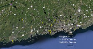
Supermarkets do it. Telecommunications companies do it. Public health departments do it. Police departments do it. They use geographic information systems (GIS) mapping to improve the way they do business. It is about time the advancement profession uses it. We at Copley Raff are finding many applications for this technology to help elevate programs to the next level.
GIS mapping has widespread applications to the work we do, and for almost any nonprofit sector. This technology enables fundraisers to plot on a map the location of your: $100+ donors; loyal donors; subscribers; patients; alumni; food recipients; ticket buyers; gala attendees and so much more.
The most important qualities of GIS mapping are that it is visual and multi-dimensional. You can overlay profiles to learn about phenomenon that can drive your strategy.
In healthcare, you can overlay $500+ donors with the sources of your highest rated patients and compare any donor clusters with demographic data from the census. This can reveal “hot spots” for direct mail, or finding volunteers from those clusters who can become mavens for our cause.
Cultural organizations can plot subscribers and overlay the location of other cultural organizations to discover if there are synergies between your museum and the theatre company near your clusters of subscribers. Perhaps new alliances can be formed.
Environmental organizations can map locations of brownfields for instance and overlay that with larger donors to mount a targeted major gift campaign to address the brownfield issues in their backyard.
And in this age healthcare reform you can locate “hot spots” for asthma or diabetes and find leadership donors who want to make their community healthier, and the accountable care organization responsible for those hot spots can target direct mail to local health concerns.
It is incumbent on the advancement profession to use the latest tools to refine and improve our work and our successes.
Your takes:


